Google Maps Immersive Navigation Is Redefining the Future of Driving
Navigation apps have become an essential part of modern driving. Whether commuting through crowded cities or planning long road trips, millions of drivers rely on digital maps every day. Now, a major redesign of Google Maps is promising to change that experience dramatically.
The latest update introduces Immersive Navigation, a new driving interface that blends advanced 3D visuals with artificial intelligence to make navigating roads more intuitive. The upgrade represents one of the most significant changes to Google Maps in more than a decade, transforming the familiar navigation tool into something that feels closer to a new app altogether.
With more realistic maps, smarter route insights, and AI-powered assistance, this update signals a shift toward a new era of digital navigation.
A Major Evolution for Google Maps
For years, Google Maps has focused on simple turn-by-turn directions and real-time traffic information. While these features remain core to the app, the new update expands the concept of navigation.
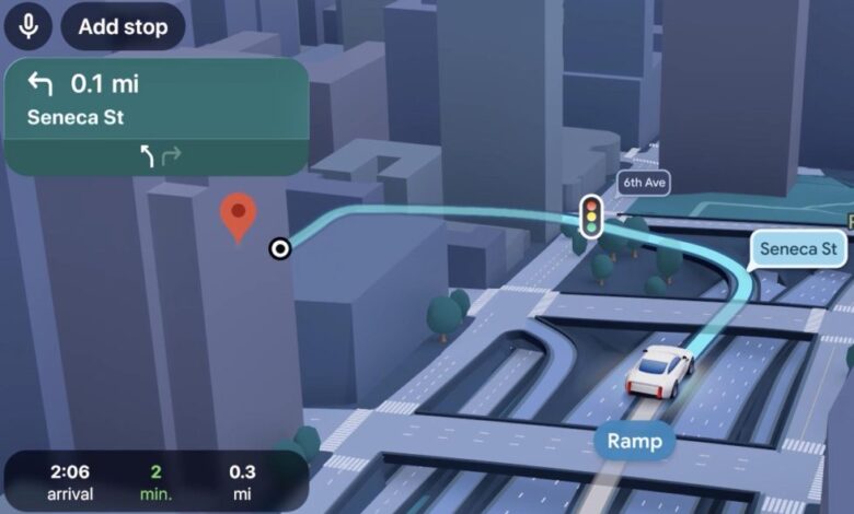
Immersive Navigation introduces a redesigned map view with enhanced depth and detail. Instead of the traditional flat map interface, drivers now see a 3D-style environment that represents buildings, road structures, terrain, and surrounding landmarks more clearly.
This change is more than a visual upgrade. It aims to solve a common issue many drivers face: confusion at complex intersections, highway exits, or unfamiliar urban roads.
With more realistic visual cues, drivers can quickly understand where they need to go without relying solely on arrows or voice instructions.
What Is Immersive Navigation?
Immersive Navigation is designed to give drivers a clearer and more natural understanding of their surroundings while using Google Maps.
The feature combines several technologies:
- Detailed 3D map rendering
- Intelligent camera angles that adjust automatically
- Highlighted road features and lane indicators
- Contextual driving guidance powered by AI
The result is a navigation system that looks and behaves more like a digital driving companion rather than a simple map.
For example, when approaching complicated junctions or highway exits, the interface can zoom in and highlight specific lanes, helping drivers prepare for turns in advance.
This reduces the need for last-second lane changes and improves overall safety and confidence behind the wheel.
Smarter Visual Guidance for Drivers
One of the biggest improvements in Immersive Navigation is the way the map adapts to different driving situations.
Instead of showing the same view throughout the trip, the interface dynamically adjusts based on where the driver is and what lies ahead.
Some of the visual enhancements include:
- Transparent buildings that reveal roads hidden behind tall structures
- Dynamic zoom levels that adjust when approaching intersections
- Highlighted lanes to show exactly where drivers should position their vehicle
- Realistic terrain and landmarks that mirror the physical environment
These features aim to eliminate the guesswork drivers sometimes experience when relying on traditional map views.
According to reports, the update uses advanced mapping data and artificial intelligence to create a clearer understanding of road infrastructure in real time.
AI Is Now Part of the Navigation Experience
The transformation of Google Maps is closely tied to the integration of Google’s latest artificial intelligence technology.
The new system leverages Gemini, Google’s AI platform, to improve route planning, voice guidance, and contextual information during a trip.
AI plays a role in several areas:
- Predicting the best routes based on traffic conditions
- Offering smarter voice instructions
- Providing contextual information about roads, construction, or delays
- Helping drivers anticipate upcoming decisions
Instead of simply saying “turn right in 500 meters,” the navigation system can provide more natural guidance, similar to directions from a human passenger.
This could include references to nearby landmarks or clearer explanations of complex road layouts.
Street-Level Previews Before You Arrive
Another feature connected to Immersive Navigation allows drivers to preview their destination before they get there.
By combining the map interface with Street View imagery, Google Maps can show what a location looks like in the real world, including building entrances and nearby parking areas.
This helps drivers answer practical questions before arriving, such as:
- Where is the entrance to the building?
- Which side of the street should I stop on?
- Is there nearby parking?
For urban environments where navigation can be confusing, this feature could significantly reduce the stress of finding the final stop.
Understanding Route Trade-Offs
Beyond basic navigation, the new interface also helps drivers understand why certain routes are recommended.
For example, if multiple routes are available, the system may show:
- Travel time differences
- Traffic congestion levels
- Toll roads versus toll-free options
- Fuel efficiency considerations
By presenting these trade-offs clearly, drivers can make more informed decisions about which route to take.
Instead of simply choosing the fastest option, they can weigh factors like cost, distance, and road conditions.
A Companion Feature: Ask Maps
Alongside Immersive Navigation, Google has introduced another feature called Ask Maps, which uses AI to answer location-related questions in a conversational way.
This feature allows users to ask natural questions such as:
- “Where can I find a quiet café nearby?”
- “Plan a road trip with scenic stops.”
- “Show me restaurants with outdoor seating.”
The AI analyzes reviews, photos, and user preferences to deliver tailored recommendations.
While Immersive Navigation focuses on the driving experience, Ask Maps aims to transform Google Maps into a broader local discovery platform.
Together, these features show how the app is evolving beyond traditional navigation.
Availability and Rollout
The new navigation experience is beginning to roll out in stages.
Initially, Immersive Navigation is launching in the United States and will be available on multiple platforms:
- Android smartphones
- iOS devices
- Apple CarPlay
- Android Auto
- Vehicles with built-in Google software
The company plans to expand access to additional regions in the coming months.
As with many large updates, some features may appear gradually as the system continues to develop.
Why This Update Matters
The navigation app market is highly competitive. Several alternatives offer mapping and routing services, but Google Maps remains the most widely used option worldwide.
By introducing a visually richer interface and AI-powered features, Google is reinforcing its position in the navigation space.
This update reflects several broader trends in technology:
- AI-powered user experiences
- More realistic digital interfaces
- Greater integration between software and real-world environments
Navigation apps are no longer just tools for directions. They are becoming intelligent assistants capable of understanding context and providing personalized guidance.
The Future of Digital Navigation
The launch of Immersive Navigation hints at where mapping technology may be headed.
Future updates could bring even more advanced features, such as:
- Augmented reality driving assistance
- Predictive travel planning
- Real-time hazard detection
- Personalized navigation experiences
As mapping data improves and artificial intelligence becomes more sophisticated, navigation systems will likely become more interactive and responsive.
In many ways, the latest Google Maps redesign is only the beginning of that transformation.
Final Thoughts
Google Maps has been a staple of smartphone navigation for years. However, the introduction of Immersive Navigation marks a turning point for the platform.
By combining detailed 3D mapping, AI-driven insights, and improved route visualization, the update creates a driving experience that feels more intuitive and immersive.
Instead of simply following arrows on a screen, drivers can now interact with a navigation system designed to mirror the real world.
As the feature continues to roll out globally, it could change how millions of people navigate roads every day.